The Meadow Creek Stream Valley comprises about 42 acres of wooded land, along the creek, that has been acquired over the years by the City. It essentially forms an L shape running along the neighborhood's west border and then turning to bisect the neighborhood. The creek has been a source of enjoyment and a place for exploration for the neighborhood since its beginnings.
Significant changes occurred to the park over the last decade or so -- most notably the 2010 replacement of a main sewer line running the length of Meadow Creek (The "Meadow Creek Interceptor"). The project, which really started in 2007, resulted in clearing a 40-foot-wide swath of woods along the length of the creek which will permanently be kept clear of significant trees that could have root structures that could damage the pipe (Click here for project "fact sheet.") Lots of trees were lost as part of the project, but it has opened up the corridor in a way that has made the creek more inviting to a larger number of people. The clearing also created a logical location in places for a multi-use trail.
At the same time the sewer project was being planned and constructed, the Nature Conservancy came up with a plan to use almost $4 million in grant funding to rehabilitate the creek bed along most of the Greenbrier stream valley. For reasons now lost to time, the City or a developer had straightened the creek in the late 1960s, taking out the natural meanders. Thereafter, the creek was further badly degraded by years of heavy runoff from large hard surface areas such as Barracks Road Shopping Center. By 2005, the creek was in very poor health, and the Nature Conservancy began to see it as an opportunity, in the Conservancy's own back yard, to undertake a major urban creek rehabilitation project.
The rehabilitation process started in 2011, very shortly after the sewer line replacement project finished. The rehabilitation included tearing down the steep banks of the stream channel and putting meanders back in. The Nature Conservancy also cleared invasive species of plants along the sides of the creek and replanted native species. The grant calls for the Conservancy to continue to monitor and fix problem areas that may arise for 10 years -- i.e., until about 2022. (Click here for fact sheets on Stream Restoration Project.)
Stream Valley Park Plan
After years of muddy construction along the creek, the neighborhood was eager to move forward with a vision for its future, and the Parks and Rec Department engaged with the neighborhood in a master planning process through a series of meetings between November of 2012 and February of 2013.
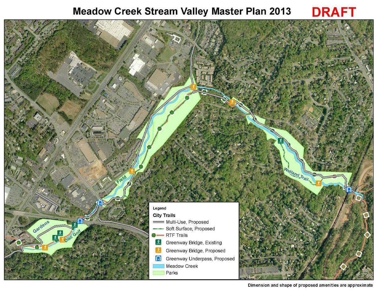
The plan that was developed and adopted by City Council in June of 2013 calls most notably for a multi-use trail (i.e., usable by bikes, strollers, runners, and walkers of all ages) along the entire length of the creek. The trail will ultimately connect -- via a tunnel under the railroad tracks -- to the paved path next to the John Warner Parkway, thereby allowing an easy, pleasant off-road connection to downtown or Rio Road and beyond to the North.
Implementation of the plan unfortunately has been slow, due to the long process of getting flood plain studies done for federal governmental approvals, as well as engineering and design work. Finally, construction of the first phase began in 2018 and after a long muddy process was finished in 2019. So we now have an 8 foot wide crushed stone path along the creek from Brandywine to the railroad tracks at the other end of Greenbrier Park. Unfortunately, in September of 2021 high flood waters knocked one of the boardwalks off its piers, making the boardwalk slant significantly from side to side. The GNA and individual advocates have been pushing the City to get it fixed. The City says it has a contractor and hopefully is will get fixed by the end of the Summer.
Below is the overall map of the approved plan (it is no longer a "draft" so ignore the left over marking).
Significant changes occurred to the park over the last decade or so -- most notably the 2010 replacement of a main sewer line running the length of Meadow Creek (The "Meadow Creek Interceptor"). The project, which really started in 2007, resulted in clearing a 40-foot-wide swath of woods along the length of the creek which will permanently be kept clear of significant trees that could have root structures that could damage the pipe (Click here for project "fact sheet.") Lots of trees were lost as part of the project, but it has opened up the corridor in a way that has made the creek more inviting to a larger number of people. The clearing also created a logical location in places for a multi-use trail.
At the same time the sewer project was being planned and constructed, the Nature Conservancy came up with a plan to use almost $4 million in grant funding to rehabilitate the creek bed along most of the Greenbrier stream valley. For reasons now lost to time, the City or a developer had straightened the creek in the late 1960s, taking out the natural meanders. Thereafter, the creek was further badly degraded by years of heavy runoff from large hard surface areas such as Barracks Road Shopping Center. By 2005, the creek was in very poor health, and the Nature Conservancy began to see it as an opportunity, in the Conservancy's own back yard, to undertake a major urban creek rehabilitation project.
The rehabilitation process started in 2011, very shortly after the sewer line replacement project finished. The rehabilitation included tearing down the steep banks of the stream channel and putting meanders back in. The Nature Conservancy also cleared invasive species of plants along the sides of the creek and replanted native species. The grant calls for the Conservancy to continue to monitor and fix problem areas that may arise for 10 years -- i.e., until about 2022. (Click here for fact sheets on Stream Restoration Project.)
Stream Valley Park Plan
After years of muddy construction along the creek, the neighborhood was eager to move forward with a vision for its future, and the Parks and Rec Department engaged with the neighborhood in a master planning process through a series of meetings between November of 2012 and February of 2013.
The plan that was developed and adopted by City Council in June of 2013 calls most notably for a multi-use trail (i.e., usable by bikes, strollers, runners, and walkers of all ages) along the entire length of the creek. The trail will ultimately connect -- via a tunnel under the railroad tracks -- to the paved path next to the John Warner Parkway, thereby allowing an easy, pleasant off-road connection to downtown or Rio Road and beyond to the North.
Implementation of the plan unfortunately has been slow, due to the long process of getting flood plain studies done for federal governmental approvals, as well as engineering and design work. Finally, construction of the first phase began in 2018 and after a long muddy process was finished in 2019. So we now have an 8 foot wide crushed stone path along the creek from Brandywine to the railroad tracks at the other end of Greenbrier Park. Unfortunately, in September of 2021 high flood waters knocked one of the boardwalks off its piers, making the boardwalk slant significantly from side to side. The GNA and individual advocates have been pushing the City to get it fixed. The City says it has a contractor and hopefully is will get fixed by the end of the Summer.
Below is the overall map of the approved plan (it is no longer a "draft" so ignore the left over marking).
The entire adopted park plan can be accessed by clicking here. It includes an interesting history of the stream valley area.
After the adoption of the plan, it was learned that Kroger was considering moving from its present location on Hydraulic to Seminole Square, in the old location for the Giant grocery store behind K-Mart. City Staff then worked with the developer and reached an agreement that, during construction while Kroger would be building out the back of the store, it will also create a trail connection so that users of the multi-use trail next to the creek will be able to go directly up to the Seminole Square shopping center. Unfortunately, by mid - 2017 Kroger had decided not to move from it's Hydraulic location and so the status of this link remains uncertain.
In 2021 a new development idea has been proposed to add significant housing at Seminole Square by tearing down some of the existing store fronts and replacing them with multi-story apartment/condos. The developer seems happy to allow an easement for a multi-use path to connect down to the stream valley but is not offering to build the connection which would require special permits which in turn allows the City more leverage over what the developer is allowed to do on the property. The developer understandably from it's perspective wants to be able to proceed with plans "by right" and not have to bend to City planners ideas of what should and shouldn't been built.
In May of 2017, another nice potential connection was worked out that gives the City an easement which will in the future allow a path connection to the Meadow Creek trail directly from Rt 29 using and going through a stand of woods between the post office and Seminole Square Shopping Center.
These connection will be significant enhancements to the trail, but we need to make sure the City staff does not use it as an excuse to avoid finishing the adopted plan which calls for a multi-use path going under Hydraulic Road using the existing culvert. As indicated above, the multi-use trail is designed to also go under Route 250 in an existing culvert and connect to Morton Drive behind the English Inn and Bodo's. Dominion Power has now donated $20,000 toward making the existing Route 250 culvert usable for a multi-use trail, and the City engineers have reportedly pretty much finished the design phase for implementation.
Click here to see the exciting overall area trail plan and learn more about the history of, and proven level of community desire for, multi-use trails -- along with information about funding.
Disc Golf Course was created in 2015 largely by enthusiasts and with some assistance of the City. It is in what had been the Old Fairgrounds area behind Bodo's and uses both sides of Meadow Creek. It is open for play. (click here for more info)
