The City's 5 year master plan update process was way behind schedule and moving mighty slowly for a couple years, but the City hired an expensive consultant and the processes picked up steam in the Spring of 2021 when a draft Future Land Use Map (FLUM) was released. The FLUM guides future zoning changes and thereby affect housing/building development.
Zoning ordinances are the key and rather blunt instrument local governments use to try to manage growth and development. Note that it is not the City that then comes in and makes changes to reflect the new zoning map. It is instead, private developers and property owners that actually do the building / tearing down etc based on their own decisions and guided by what is allowed by the zoning ordinances or exceptions they can get to the zoning ordinances.
As we have heard for a while -- there is an overarching drive by City leaders to make more density possible throughout the City and further target specific areas for significantly increased density. The goal is to create more mixed income housing and more workforce and affordable housing opportunities, as well as just planning to accommodate the expected rise in population within the City limits.
The release of the draft FLUM lead to a great deal of comments both pro and con but citizens. Indeed, our neighborhood had a robust useful discussion of views on our group email list (which few times got too heated leading to some warnings being issued to the individuals involved by the GNA Exec Committee).
As with past "hot" issues with divided thought in the neighborhood -- the GNA did NOT take a position on the FLUM. Instead, the GNA tried to keep our residents informed of the facts, events, and opportunities and ways to give personal input to the decision makers.
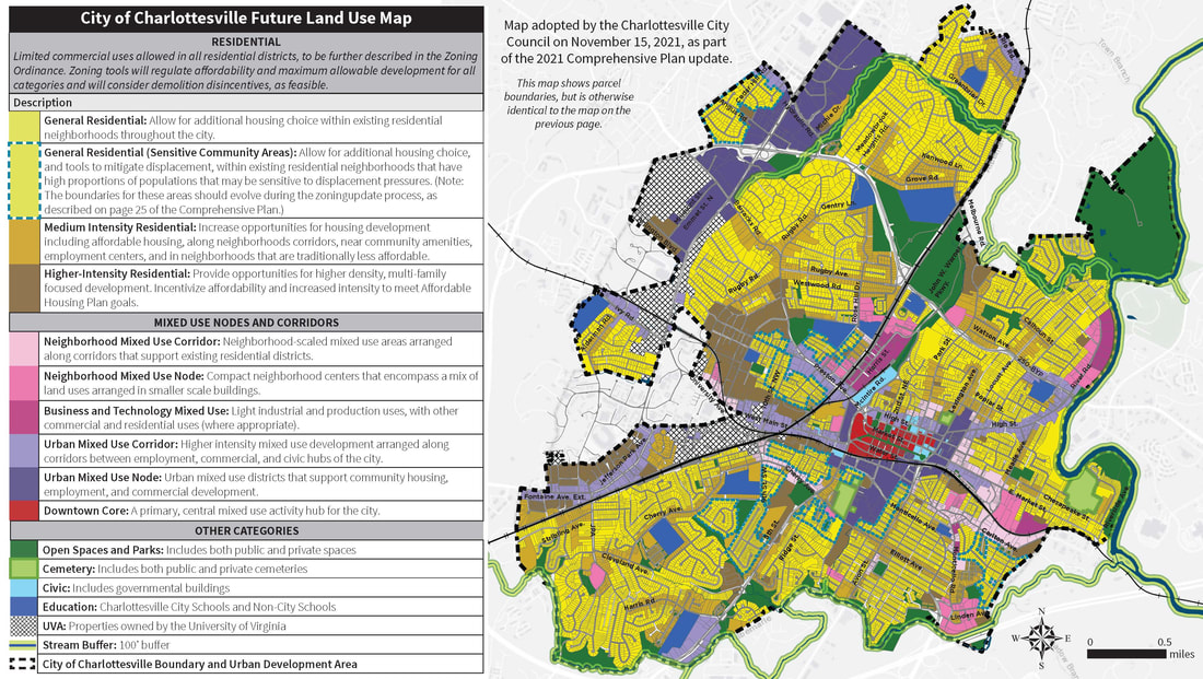
The FLUM was then revised based on feed back from the community and at the end of 20211 City Council adopted a final version of the map as part of adopting the whole Five Year Comprehensive Plan.
Under the final version you will see pictured below
Most of our neighborhood (like other residential areas) would be in a category described as follows:
"General Residential: Allow for additional housing choice within existing residential neighborhoods throughout the city."
A higher density under the map, however, would be possible for: (1) Meadowbrook Heights near the 250 Bypass; (2) the roads around CHS; (3) the roads around Greenbrier Elementary; (4) Greenbrier, and Banbury near Rio Rd -- the designation is described as follows:
"Medium Intensity Residential: Increase opportunities for housing development including affordable housing, along neighborhoods corridors, near community amenities, employment centers, and in neighborhoods that are traditionally less affordable."
Again while the adopted map will be a guiding document it will be the Zoning ordinances that the City will be considering in the coming months that are critical in what ultimately will and won't be allowed in any given area. The City planners are looking for input in the coming months and at the end of June 2022 put out a many page document on what Zoning changes would mean with a lot of useful diagrams and pictures of what development could look like under each proposed category.
The planning goal is for Council to adopt the new overhaul of Zoning ordinances in the first quarter of 2023. Please let your thoughts be heard.
You can sign up for updates or just follow the action on the City's web page set up for this purpose https://cvilleplanstogether.com/
.
Zoning ordinances are the key and rather blunt instrument local governments use to try to manage growth and development. Note that it is not the City that then comes in and makes changes to reflect the new zoning map. It is instead, private developers and property owners that actually do the building / tearing down etc based on their own decisions and guided by what is allowed by the zoning ordinances or exceptions they can get to the zoning ordinances.
As we have heard for a while -- there is an overarching drive by City leaders to make more density possible throughout the City and further target specific areas for significantly increased density. The goal is to create more mixed income housing and more workforce and affordable housing opportunities, as well as just planning to accommodate the expected rise in population within the City limits.
The release of the draft FLUM lead to a great deal of comments both pro and con but citizens. Indeed, our neighborhood had a robust useful discussion of views on our group email list (which few times got too heated leading to some warnings being issued to the individuals involved by the GNA Exec Committee).
As with past "hot" issues with divided thought in the neighborhood -- the GNA did NOT take a position on the FLUM. Instead, the GNA tried to keep our residents informed of the facts, events, and opportunities and ways to give personal input to the decision makers.
The FLUM was then revised based on feed back from the community and at the end of 20211 City Council adopted a final version of the map as part of adopting the whole Five Year Comprehensive Plan.
Under the final version you will see pictured below
Most of our neighborhood (like other residential areas) would be in a category described as follows:
"General Residential: Allow for additional housing choice within existing residential neighborhoods throughout the city."
A higher density under the map, however, would be possible for: (1) Meadowbrook Heights near the 250 Bypass; (2) the roads around CHS; (3) the roads around Greenbrier Elementary; (4) Greenbrier, and Banbury near Rio Rd -- the designation is described as follows:
"Medium Intensity Residential: Increase opportunities for housing development including affordable housing, along neighborhoods corridors, near community amenities, employment centers, and in neighborhoods that are traditionally less affordable."
Again while the adopted map will be a guiding document it will be the Zoning ordinances that the City will be considering in the coming months that are critical in what ultimately will and won't be allowed in any given area. The City planners are looking for input in the coming months and at the end of June 2022 put out a many page document on what Zoning changes would mean with a lot of useful diagrams and pictures of what development could look like under each proposed category.
The planning goal is for Council to adopt the new overhaul of Zoning ordinances in the first quarter of 2023. Please let your thoughts be heard.
You can sign up for updates or just follow the action on the City's web page set up for this purpose https://cvilleplanstogether.com/
.
You can get a PDF of this March 2021 Draft Land Use Map using this link.
